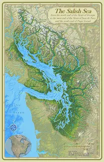
("The Salish Sea Map, Stefan Freelan, WWU, 2009")
In late 2009, naming boards in both Canada and the U.S.A. granted approval to use the name, “Salish Sea” for a body of water that extends from the north end of the Strait of Georgia and Desolation Sound to the west end of the Strait of Juan de Fuca and south to the southern extent of the Puget Sound including the inland marine waters of southern British Columbia, Canada and northern Washington, USA. These separately named bodies of water form a single estuarine ecosystem. The new name for these waters has been embraced by citizens on both sides of the border, including the Coast Salish Gathering (the alliance of Coast Salish Tribal and First Nations leaders).
 Salish Sea is not a historical term for the inland waters of British Columbia and Washington State. Marine biologist Bert Webber proposed it in 1988. Dr. Webber recognized the need for a single geographic term that encompassed the entire ecosystem, spanning across the international border. Having a name to identify the entire area calls attention to the trans-border commonality of water, air, wildlife and history. Rather than being a replacement for any of the existing names, the designation Salish Sea is an overlay that includes and unites the established and familiar names of the various water and land bodies (the Strait of Georgia, Strait of Juan de Fuca, Puget Sound, Gulf Islands, San Juan Islands, etc.). The name also pays tribute to the Coast Salish peoples who have inhabited the area since long before Euro-American explorers first arrived.


0 comments:
Post a Comment